Showing posts with label #OpenSkies. Show all posts

August 19, 2017

Russian Open Skies Treaty overflight of the USA, August 2017 edition

Refer to previous posts I've written on the Open Skies Treaty for background; this post is just to get you the map with all the flight information available from FlightRadar24.

While elements of the media have been focused on the "outrage" of the "low-level" flight over the Pentagon, Camp David, and Trump's golf course, I've been laughing at the other obvious targets of their photography; including one of my favourite military targets; Site R.  Several military bases, Navy facilities, Shipyards, Ammunition Depots, etc.. were photographed as well.  Their altitude (~4000ft) suggests a digital panoramic camera is being used, but I don't have confirmation of that. The treaty mandates a maximum of 30cm resolution, which is less detailed than commercial satellite imagery, but the camera is certified as being tamper-proof, and the imagery can (is) shared among all 34+ signatories of the treaty.

Anyone telling you the Russians are using the Open Skies Treaty for purposes it wasn't intended to be used for has not read the treaty, or has ulterior motives.  Don't believe the hype, look for yourself.  Zoom in on the map below, look up your favourite East Coast military facilities.  A reminder tho; military targets are not always military buildings or property.  Tanks could be sitting in a rail yard, and could be just as valuable to check out year to year. General Dynamics or other defense contractors might be performing tests at a civilian owned property.  Some very poorly informed people have even suggested the treaty has something to do with missiles. It does not. The treaty covers everything and anything they want it to cover; and that's how it works for our overflights of Russia as well.

Unfortunately, the "new" low altitude (by comparison w/ former ~10,000ft) flights makes it hard to triangulate the transponder using MLAT, so the flight route is spotty.  Many of the targets are quite obvious.  Also of note, the "swath" that the camera catches in the frame is large; I'm not sure how large with that camera at 4,000ft, but they do not need to be "over" something to get a good picture of it.


August 17, 2017

Two Russian Open Skies Treaty aerial observation missions over the USA in June 2017

If you're unfamiliar with the Open Skies Treaty, I've written quite a bit about it before, and I highly recommend leafing through the old blog posts to get up to speed.

What you're about to read is coverage that no news organisation (that I'm aware of) is providing you, because USAF policy is to not talk about Open Skies Treaty observation flights.  Yes, like Fight Club. Since no press releases are put out by the USAF, no US media cover the flights, because they don't know what to say, and all the USAF personnel who could say something, are not allowed to per USAF policy.  Page 30, Section 4.2.1.1.4.7, Air Force Manual 16-604 (2009) "posture for OST flights is “passive.” (we) respond to inquiries, but (don't) promote activities" while that does not specifically state that USAF personnel are not allowed to talk about it, the information is classified (a low-level classification) and the treaty is obscure.  If the US Media were trying to confirm when a flight was happening, IF it was happening, their first source would be TASS or Sputnik, which would immediately raise red flags to Western Media editors. After all, why believe these agents of disinformation and Russian propaganda?  Well, maybe because they're the only people who publicise the treaty overflights; of the US over Russia, or Russia over other countries.  Why is it that only Russia tells their people about a 34+ nation treaty that's working extremely well? Why doesn't the US government want their citizens to know they exercise their treaty rights to overfly Russia, and Russia does the same to the USA, on an almost monthly basis?

I don't know. It's a complete mystery to me.

The Russian Federation performed two scheduled aerial observation missions over the United States under the terms agreed upon by the 34-35 nations in the Treaty on Open Skies, or Open Skies Treaty as it is commonly referred to, between June 19th and June 30th, 2017. Per treaty rules, they left, stopped at CFB Trenton, and went back in between overflights.

June 19 - June 23, 2017

The Russian team flew in to Travis AFB, on their Treaty-approved Tupolev Tu-154M, and recently outfitted digital camera, from Moscow, on Monday, and likely negotiated the flight plan they proposed on Tuesday morning with the American team. The US team is assigned to escort them in their observation plane and ensure all restrictions of the overflight are adhered to; heights are as promised, courses are adhered to, etc. From Tuesday to Thursday (Thursday is when the observation flights started) the US military and defence industry would have been alerted, and would likely have been covering up/moving any equipment they did not want photographed that was along the flight path.  This is standard procedure, and known to be a cat and mouse game.  Anything too big to move will simply be photographed, but these flights, while short notice, can be anticipated to a certain extent. They are routine, happen half a dozen times a year, and I don't think any out-in-the-open testing is ever performed without consideration regarding it being photographed by satellites or the Open Skies Treaty overflights.  After all, the Russian Federation (and the Chinese) also have satellites which can (at least) see the visual spectrum, and may also be outfitted with space-borne Synthetic Aperture Radar. After a brief tour of California, the Russian team (with their American handlers aboard) went to Alaska.  Unfortunately, FlightRadar24 and ADSBExchange have terrible coverage up there, and little of the flight was captured by transponder.  From what I gather that may or may not have overflown several air force bases including missile launch facilities.


June 26 - June 30, 2017

The second week's flights took place first over Texas at a low altitude (5000ft), then after a brief stop to uncover the belly mounted framing camera, continued at a higher altitude. On Friday they finished off the New Mexico leg of the trip, overflying many famous historical nuclear test, development, and production facilities.


But what did they take pictures of?  Well, that's an excellent question. I don't know, but I can make some educated guesses, and you can too,  if you follow along:

  • Open Skies Treaty flights are based on a negotiation of a flight plan that is proposed by the overflying party. The observed party can argue or debate which route to the locations might be best, if poor weather is expected, or if cloud cover will hamper the trip, they can propose alternate routes or sites. Ultimately, the overflying party can refuse the options and insist on the flight plan they want, and if the overflown party objects, they need to cancel the whole trip, with causses a major international incident.  But, there are some things that are constant on these flight plans (from studying past flight plans); steady speed and constant height are tell-tale signs of photos being taken. When the flight plan is agreed to, there are legs, and for each leg an altitude is selected which will place the camera at the correct distance from the ground to get 30cm imagery.  Same with speed; they want the speed of the aircraft to be consistant. Usually the height is between 8000-12000ft and the speed between 300-350kts.  On the maps I've marked potential sites in the right speed envelope in green (based on my best estimate). If the plane is doing 500kts, they aren't taking pictures. If they're at 34,000ft, they aren't taking pictures either. If they're at 8,000ft, and doing 300kts, you can bet they're taking pictures, or are lining up for the shot.
  • American military or defence installations are sometimes pretty easy to spot along the line, especially if they're extremely remote.  If in the middle of a desert there's a runway, some fiel tanks, and some buildings... congratulations you've found some semi-secret remote military industrial complex test site, or where they keep the aliens; you get the idea.  If the speed of the plane is between 300-350, and the height is stable, that's the sweet spot, and you know there is either something there, something was there previously, or they thought something could be there, and wanted a closer look.
  • Open Street Maps makes it easy to spot government facilities, as they're usually large pink sections of the map. Have a look at https://www.openstreetmap.org/ if you're struggling to name a site, and you might find it spelled out to you.
This is an Open Skies (OS) Format 14 document, submitted to the Canadian RCAF by the Russian RuAF at the conclusion of one of their Open Skies Treaty flights over Canada.


As I've pointed out previously, there is absolutely no reason any American reading this couldn't request (via FOIA) from the USAF, State Department, or DTRA, ALL the flight plans documented on Open Skies Format 14 templates (like the above) from 2002 to present day.
That will tell you exactly what legs were flown, and where the pictures were taken.

So what are you waiting for?

May 19, 2017

Russian Observation flights over the United States, again. (May 18-19 2017)

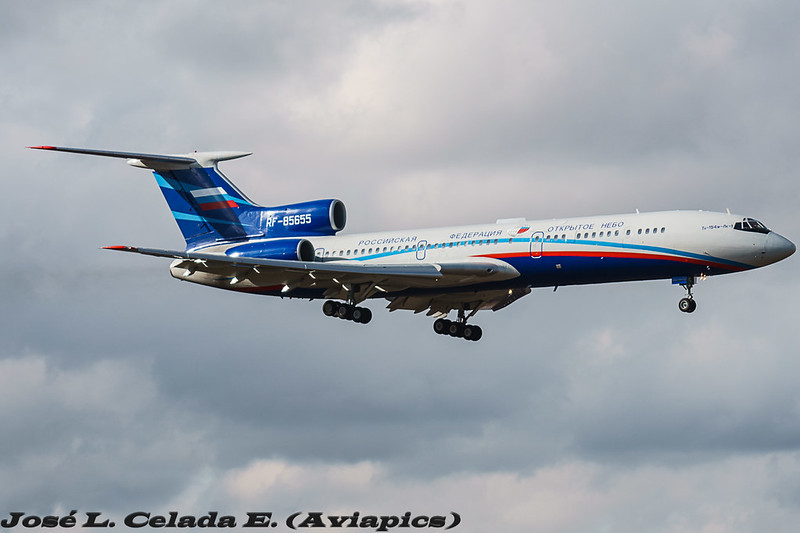
T-154M-LK1 RF-85655
I've written a lot about the Open Skies Treaty (here), and this week the Russian Federation Open Skies Treaty certified Tu-154M is once again in the skies over the United States.  There has been less media coverage this time, perhaps because the media didn't realize these flights normally happen once every month or two, and over cycled just weeks ago.  In short, 34 nations are signatory to the treaty, that lets the signatories overfly each others territory, with short notice, and members of the overflown nation's military on board, to take 30cm resolution pictures of sites of interest.  30cm is the defined maximum image resolution, and was the same when the Russian's used wet film.  The rest of the countries still use wet film, so far. This time, the Russians flew into Travis AFB on the West Coast, after stops for fuel in Iceland and Canada, and started observation flights Thursday March 18th 2017.  The flight plan would have been tabled either late Monday or early Tuesday, and a memo to all US Military (and related to military) sites that were going to be overflown would have been sent to ensure all unicorns were in their stables, and all stolen alien technology was back underground at Area 51, or, you know, whatever.

Here is a quick and dirty map of the locations they overflew. Why? Well, think of it this way. The sites that the RuAF are taking pictures of have been requested by the Russian Intelligence Community.  Something at these sites is interesting to someone, likely in the Russian defence industry.  But don't they have Google Maps?  Yes, but Google Maps / Bing / Nokia are all routinely tampered with by "Agencies", and the services are happy to do so to keep on governments' good sides. Entire airports can be removed and farms photo-shopped in. Buildings are over-exposed to blot out what's on top. Facilities are entirely pixelated.  Imagery is overtly tampered with, shadows moved, objects cloned. What you see on Google Maps is what the government is allowing you to see; Russia knows that.  While 30cm resolution isn't the greatest commercially available, it is good enough to show tanks loaded on rail cars, new buildings that have cropped up out of nowhere, etc.. They know their camera, and the pictures it takes, have not been tampered with.

Using its new-last-year Digital Electro Optical sensor, the flight has been basing itself out of Travis AFB in California, and at the end of the first day of observation flights, I believe it has taken pictures of the following locations, based on the altitude and airspeed.  Looking at the map below, and where you see a red dot, the plane was between 290-310kn, the sweet spot to take pictures.


Friday May 19th was the 2nd day of overflights and the Russians plotted a very similar route to what they flew in September of 2016.  Unfortunately, they varied their speed more than May 18th so it was a little harder to nail down exactly what they were taking pictures of.  My educated guesses are below:


With two observation flights complete, the Russians flew the first leg of their trip back to Moscow on May 20th, stopping for an overnight stay in Canada at CFB Trenton, which is a treaty approved refuelling stop.  All countries which are signatory to the Treaty on Open Skies must provide logistical support to Open Skies Treaty transit flights.

Russian Open Skies Observation Mission Over USA (April 13-14 2017)

April 13-14th 2017 the Russian Federation conducted an overflight of the United States in compliance with the Open Skies Treaty, with members of the USAF on board.

You will notice the sites along the Eastern Seaboard are all at locations where the Russian Navy AGI Viktor Leonov AGI spotted in February and March.  Coincidence? Absolutely not.  The Viktor Leonov's mission is to profile subs, investigate coastal radar, sonar, subsurface sensors, etc. The Open Skies Observation flight was more than likely to check out the same sites it was performing ELINT on, to "see" from above the interesting things it picked up while it was at least 12 nautical miles from shore.


October 03, 2016

DND downplays operational impact of Open Skies restrictions by Russia, contrasting the DoD

(U) Canadian and American airmen load wet film in an observation camera
 Photo by Public Affairs Photographer Warrant Officer Robert Granger,
Director General Public Affairs, Ottawa. (IS2007-6013)
Exercising their Open Skies Treaty right, the Russian Federation performed overflights of Eastern Canada at the end of August 2016. The Treaty on Open Skies is a transparency / arms control and verification agreement between 34 countries, which Canada and Russia are signatory to.  Since there was no press release put out by the Department of National Defence about the overflight, I requested an interview to discuss the recent overflight, and other Open Skies topics, with a representative of the Department of National Defence.  Lieutenant-Colonel Veillette, Section Head of Strategic Joint Staff, Arms Control and Verification 4, agreed to meet and speak with me, on the record.

As background to this, you may recall the testimony before congress of Admiral Cecil Haney (Commander, U.S. Strategic Command) February 24th 2016 at the meeting of the U.S. House Armed Services Committee on U.S. Strategic Forces Posture, if not here it is. You may remember Marine Corps Lt. Gen. Vincent Stewart (Director of the Defense Intelligence Agency) speaking at the March 2nd 2016 House Armed Services Committee hearing on World Wide Threats; if not, here it is.  You may remember Mr. Brian P. Mckeon (Principal Deputy Under Secretary of Defense for Policy, Department of Defense) speaking at the April 14th 2016 Senate Armed Services Committee hearing on Missile Defeat Posture and Strategy of the United States; if not, here it is.  To sum up, they all spoke rather negatively about Russia and the Open Skies Treaty, painting the Russians as abusing the spirit of the agreement and using it to conduct "foundational intelligence", as well as slamming the Russians' plans to upgrade to an "electro-optical sensor" from wet film.  Perhaps you recall their depiction of the restrictions to Open Skies flights over Russia, phrased to suggest the flights were blocked, when they were not.  Perhaps you remember that Russia was being accused of being in contravention of the treaty.  Then there was the 2016 United States Department of State Compliance Report (here) that outlined what were supposed to be major violations of the treaty in 2015.  There were threats of retaliation, described at length by the House Foreign Affairs Committee Chairman Ed Royce, Intelligence Committee Chairman Devin Nunes and Armed Services Committee Chairman Mac Thornberry in a letter to President Obama here.

The Russians came back to Canada for their most recent overflight, with the newly painted, and digital electro-optical sensor-outfitted, Russian Federation Open Skies-approved Tupolev Tu-154M RF-85655.  It was the first Canadian overflight by the Russians to use their new electro-optical sensor, approved by the OSCC in June 2016.  One week prior, the Russians performed an overflight of the United States, with the same digital electro-optical sensor, despite the objections raised in the spring before the congress and threats from congressmen.  Regarding what some call "advanced sensors" used on the Russian open Skies missions, Lieutenant-Colonel Veillette did not use US Lt.Gen Stewart's "Polaroid vs 1080P" comparison, voiced on March 2nd 2016 before the House Armed Services Committee hearing on World Wide Threats. Canadian Lieutenant-Colonel Veillette stated:
"30cm resolution for digital, 30cm for wet film; it's like, what's heavier? 5 pounds of iron or 5 pounds of (lead)? 30cm is 30cm." 
The Lieutenant-Colonel, in stark contrast with US officials, is clearly not worried about the new digital electro-optical sensors, which were framed as "advanced sensors" by the American media, fueled by US Government officials' statements.  Before being approved, the sensors were vetted by a multi-national team representing the nations of the OSCC; 30cm resolution is the treaty-mandated imagery resolution limit, both digital and wet film cameras must adhere to the same standards in order to be used on board an Open Skies plane.  There is no significant intelligence advantage that is provided by digital cameras, other than post processing of the original image, removing the need to process hundreds of wet film images and create print duplicates.  Changing the type of sensor from analog to digital is akin to a professional photographer switching from using a 35mm DSLR camera to a digital DSLR camera, assuming both gave the same resolution image.

When asked about Russian restrictions on the Open Skies Treaty overflights over the Russian Federation, and if they impacted the observation missions the RCAF routinely flies over the Russian Federation in those same restricted areas, Lieutenant-Colonel Veillette stated ...
". . . somewhat, but at the end I don't think the treaty is degraded by any shape or form . . . operationally it makes things a little bit more complicated, but not totally (insurmountable), there's always a way."  
Specifically on the topic of the flight distance restriction of 500km imposed over Kaliningrad:
"If I cannot see everything in 500km it doesn't mean I cannot go a 2nd time and do another 500km, if I wanted to do 1000km there; so in the end, is it degraded? Somewhat, because I would rather do it once."
...which, again, is a far cry from the Pentagon / DoD narrative which depicted the Russian-imposed restrictions as being heinous acts, stopping just short of suggesting the United States should pull out of treaty because of them.

United States Marine Corps Lieutenant general Lt. Gen. Stewart, the Director of the US Defence Information Agency, accused the Russians of spying on critical infrastructure and gathering "foundational intelligence"; suggesting that some sites being photographed in the United States by the Russians aren't military in nature, and taking observation photos of them is taking advantage of the treaty for espionage purposes.  I asked RCAF Lieutenant-Colonel Veillette about Russian Open Skies overflights taking aerial photography of infrastructure, power facilities, and other areas of seemingly questionable military value in Canada:
"people have the misconception because we're flying (a) military airplane to do those missions, that (we) are solely looking at military resources . . . every country who flies Open Skies is not solely flying over (military sites)."
Many non-military sites are valuable intelligence targets that would indicate an imminent threat to Russia; rail yards, transportation hubs, factories, power stations... all have military value, and if Canada was preparing for war, they would each show changes.  Green vehicles being moved by rail.  Machines of war being produced at domestic facilities.  Fighter jets being lined up at alternate airfields.  It isn't sufficient to just look at military bases, and Canada doesn't limit our Open Skies Treaty overflights to purely military targets in Russia either. (more here)

I was very pleased to have the opportunity to speak with Lieutenant-Colonel Veillette, and hope I will be able to do so again.  As the Section Head of SJS ACV 4, the unit which performs the Open Skies overflights by Canada, facilitates Russian overflights of Canada, and facilitates transit of Russian Open Skies missions en-route to the United States, his in-depth insight and experience clarified several topics of interest.

October 01, 2016

Russian Open Skies Treaty overflight of the USA | September 26th-30th 2016

Nevada Test Site - Gate 1
Taken April 2 2010 - Photo by Bill Ebbesen (Wikipedia)
While I don't intend to blog about every single Open Skies Treaty overflight of the United States of America by the Russian Air Force, Nevada is a hub of historically significant military sites, and continues to be a hotbed of military testing facilities, restricted airspace, and military bases. Generally, the Russian Air Force doesn't pick the places they photograph; they are the operators and tip of the spear;.  The RuAF execute requests by other agencies for imagery of American locations of interest, not just requests from the Russian Ministry of Defence. Since each Open Skies mission has a limited amount of distance it can cover, as mandated by the Treaty, the Russians do not try and fly over all of the US at once, they break it up into zones. This flight was an observation mission over California and Nevada. If you zoom in to a reasonable detail level and follow the flight path you'll find a "who's who" (a what's what?) of DoD and DoE locations, as well as other places of interest to the Russian Federation.  Reverse-engineering this flight path, you can discern where the US Military is conducting their most sensitive testing, training, research, and any number of other "interesting" things.

Previous Open Skies treaty posts here for background.

Thank you @ktul_adsb for spotting additional points of interest!

NB: RF-85655 just took off en route to CFB Trenton, Iceland, and ultimately Kubinka (Кубинка) Air Base, originating from Travis AFB where last week's mission was being based from.


September 21, 2014

NEWS: Russia to fly Open Skies treaty flights over the US between September 21 - 29

Tu-154M Lk-1
Photo Credit: Mark Kwiatkowski
It fascinates me that every time there is an Open Skies Treaty-sanctioned overflight of the US by a Russian spy observation plane (in accordance with the treaty it has US personnel on board too) there isn't a peep in the US Media.  I can only assume this is because Americans would freak out and riot of they knew they were being photographed from above by a Russian observation flight.

ITAR-TASS: Russia - Russian inspectors to make Open Skies flight over US

MOSCOW, September 21. /ITAR-TASS/. A group of inspectors will begin a monitoring flight by observation aircraft Tu-154M Lk-1 over the United States under the International Open Skies Treaty, the acting head of the Russian National Centre for Reduction of Nuclear Danger told Itar-Tass.

“An observation flight at a maximum distance of up to 4,900 kilometres will be made from September 21 to 29 from the Open Skies airfield Wright-Patterson, Ohio,” Ruslan Shishin said.

The Russian observation aircraft would make a flight on a route coordinated with a party under observation and American specialists aboard the airplane would control how monitoring equipment was used and the treaty’s clauses were fulfilled, he said.

The observation flight is made to make military activity of the signatory nations to the treaty more open and transparent and to step up security through higher confidence-building measures. This is the 30th flight Russia makes over the territory of the treaty’s signatories in 2014.

The Treaty on Open Skies was signed in 1992. As many as 34 countries joined the agreement. Observation flights are made over Russia, the U.S., Canada and European states. Open Skies top tasks are development of transparency, assistance to supervision over fulfilment of the arms control agreements, broader capacities to avert crises and settle crisis situations within the Organisation for Security and Co-operation in Europe (OSCE) and other international organisations.
http://en.itar-tass.com/russia/750548