If you're unfamiliar with the Open Skies Treaty, I've written quite a bit about it before, and I highly recommend leafing through the old blog posts to get up to speed.
What you're about to read is coverage that no news organisation (that I'm aware of) is providing you, because USAF policy is to not talk about Open Skies Treaty observation flights. Yes, like Fight Club. Since no press releases are put out by the USAF, no US media cover the flights, because they don't know what to say, and all the USAF personnel who could say something, are not allowed to per USAF policy. Page 30, Section 4.2.1.1.4.7, Air Force Manual 16-604 (2009) "posture for OST flights is “passive.” (we) respond to inquiries, but (don't) promote activities" while that does not specifically state that USAF personnel are not allowed to talk about it, the information is classified (a low-level classification) and the treaty is obscure. If the US Media were trying to confirm when a flight was happening, IF it was happening, their first source would be TASS or Sputnik, which would immediately raise red flags to Western Media editors. After all, why believe these agents of disinformation and Russian propaganda? Well, maybe because they're the only people who publicise the treaty overflights; of the US over Russia, or Russia over other countries. Why is it that only Russia tells their people about a 34+ nation treaty that's working extremely well? Why doesn't the US government want their citizens to know they exercise their treaty rights to overfly Russia, and Russia does the same to the USA, on an almost monthly basis?
I don't know. It's a complete mystery to me.
The Russian Federation performed two scheduled aerial observation missions over the United States under the terms agreed upon by the 34-35 nations in the Treaty on Open Skies, or Open Skies Treaty as it is commonly referred to, between June 19th and June 30th, 2017. Per treaty rules, they left, stopped at CFB Trenton, and went back in between overflights.
But what did they take pictures of? Well, that's an excellent question. I don't know, but I can make some educated guesses, and you can too, if you follow along:
As I've pointed out previously, there is absolutely no reason any American reading this couldn't request (via FOIA) from the USAF, State Department, or DTRA, ALL the flight plans documented on Open Skies Format 14 templates (like the above) from 2002 to present day.
That will tell you exactly what legs were flown, and where the pictures were taken.
So what are you waiting for?
What you're about to read is coverage that no news organisation (that I'm aware of) is providing you, because USAF policy is to not talk about Open Skies Treaty observation flights. Yes, like Fight Club. Since no press releases are put out by the USAF, no US media cover the flights, because they don't know what to say, and all the USAF personnel who could say something, are not allowed to per USAF policy. Page 30, Section 4.2.1.1.4.7, Air Force Manual 16-604 (2009) "posture for OST flights is “passive.” (we) respond to inquiries, but (don't) promote activities" while that does not specifically state that USAF personnel are not allowed to talk about it, the information is classified (a low-level classification) and the treaty is obscure. If the US Media were trying to confirm when a flight was happening, IF it was happening, their first source would be TASS or Sputnik, which would immediately raise red flags to Western Media editors. After all, why believe these agents of disinformation and Russian propaganda? Well, maybe because they're the only people who publicise the treaty overflights; of the US over Russia, or Russia over other countries. Why is it that only Russia tells their people about a 34+ nation treaty that's working extremely well? Why doesn't the US government want their citizens to know they exercise their treaty rights to overfly Russia, and Russia does the same to the USA, on an almost monthly basis?
I don't know. It's a complete mystery to me.
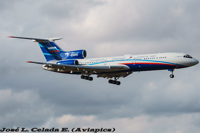
The Russian Federation performed two scheduled aerial observation missions over the United States under the terms agreed upon by the 34-35 nations in the Treaty on Open Skies, or Open Skies Treaty as it is commonly referred to, between June 19th and June 30th, 2017. Per treaty rules, they left, stopped at CFB Trenton, and went back in between overflights.
June 19 - June 23, 2017
The Russian team flew in to Travis AFB, on their Treaty-approved Tupolev Tu-154M, and recently outfitted digital camera, from Moscow, on Monday, and likely negotiated the flight plan they proposed on Tuesday morning with the American team. The US team is assigned to escort them in their observation plane and ensure all restrictions of the overflight are adhered to; heights are as promised, courses are adhered to, etc. From Tuesday to Thursday (Thursday is when the observation flights started) the US military and defence industry would have been alerted, and would likely have been covering up/moving any equipment they did not want photographed that was along the flight path. This is standard procedure, and known to be a cat and mouse game. Anything too big to move will simply be photographed, but these flights, while short notice, can be anticipated to a certain extent. They are routine, happen half a dozen times a year, and I don't think any out-in-the-open testing is ever performed without consideration regarding it being photographed by satellites or the Open Skies Treaty overflights. After all, the Russian Federation (and the Chinese) also have satellites which can (at least) see the visual spectrum, and may also be outfitted with space-borne Synthetic Aperture Radar. After a brief tour of California, the Russian team (with their American handlers aboard) went to Alaska. Unfortunately, FlightRadar24 and ADSBExchange have terrible coverage up there, and little of the flight was captured by transponder. From what I gather that may or may not have overflown several air force bases including missile launch facilities.June 26 - June 30, 2017
The second week's flights took place first over Texas at a low altitude (5000ft), then after a brief stop to uncover the belly mounted framing camera, continued at a higher altitude. On Friday they finished off the New Mexico leg of the trip, overflying many famous historical nuclear test, development, and production facilities.But what did they take pictures of? Well, that's an excellent question. I don't know, but I can make some educated guesses, and you can too, if you follow along:
- Open Skies Treaty flights are based on a negotiation of a flight plan that is proposed by the overflying party. The observed party can argue or debate which route to the locations might be best, if poor weather is expected, or if cloud cover will hamper the trip, they can propose alternate routes or sites. Ultimately, the overflying party can refuse the options and insist on the flight plan they want, and if the overflown party objects, they need to cancel the whole trip, with causses a major international incident. But, there are some things that are constant on these flight plans (from studying past flight plans); steady speed and constant height are tell-tale signs of photos being taken. When the flight plan is agreed to, there are legs, and for each leg an altitude is selected which will place the camera at the correct distance from the ground to get 30cm imagery. Same with speed; they want the speed of the aircraft to be consistant. Usually the height is between 8000-12000ft and the speed between 300-350kts. On the maps I've marked potential sites in the right speed envelope in green (based on my best estimate). If the plane is doing 500kts, they aren't taking pictures. If they're at 34,000ft, they aren't taking pictures either. If they're at 8,000ft, and doing 300kts, you can bet they're taking pictures, or are lining up for the shot.
- American military or defence installations are sometimes pretty easy to spot along the line, especially if they're extremely remote. If in the middle of a desert there's a runway, some fiel tanks, and some buildings... congratulations you've found some semi-secret remote military industrial complex test site, or where they keep the aliens; you get the idea. If the speed of the plane is between 300-350, and the height is stable, that's the sweet spot, and you know there is either something there, something was there previously, or they thought something could be there, and wanted a closer look.
- Open Street Maps makes it easy to spot government facilities, as they're usually large pink sections of the map. Have a look at https://www.openstreetmap.org/ if you're struggling to name a site, and you might find it spelled out to you.
As I've pointed out previously, there is absolutely no reason any American reading this couldn't request (via FOIA) from the USAF, State Department, or DTRA, ALL the flight plans documented on Open Skies Format 14 templates (like the above) from 2002 to present day.
That will tell you exactly what legs were flown, and where the pictures were taken.
So what are you waiting for?