June 17, 2017

Mapping the ACX Crystal's collision with the USS Fitzgerald using publicly available info

USS Fitzgerald (MMSI:338839000 Callsign:NFTZ)
(2017.06.17 edit)
Per the USNavy's 7th Fleet public affairs office;
USS Fitzgerald (DDG 62) was involved in a collision with a merchant vessel at approximately 2:30 a.m. local time, June 17, while operating about 56 nautical miles southwest of Yokosuka, Japan.

The merchant vessel was the Filipino-flagged ACX Crystal container-ship (IMO:9360611) and she did have her AIS transponder on at the time of the incident.

From the news footage below you'll notice an area of severe damage which looks to me to be from an impact at a perpendicular angle, and not a grazing strike, since there is no scraping or dragging down the length of the USS Fitzgerald. I'm not suggesting the impact was deliberate, only that the vessels would have deflected if they had hit with a glancing strike, where to me it looks like the bow of the Crystal embedded itself for a short period in the USS Fitzgerald. I originally thought the USS Fitzgerald was stationary before the impact, but I've since changed my mind, since I've been told that there would be no operational reason to be stationary near an area of high traffic, on a moonless night. Valid point. Then if she wasn't stationary, why was she crossing the path of the shipping lane and how didn't they notice the 30,000 Ton ship on a collision course with them?


Here is the MarineTraffic.com animation of the entire collision:


I have provided a Google Fusion map below, and linked to the original source data that might be useful to you if you want to do a deeper investigation into the original story yourself.


The data looks a little confusing, so watch the video to get an idea of how the strike happened. The colour coding is to show the speeds of the ACX Crystal when moving. Red is almost stopped, Green is full speed ahead.

From a discussion with JJ I think the UTC/JST conversion may have been messed up, or the reported time by the US Navy and Japanese Coast Guard was not representative of the time of the collision, only when the collision was reported.  I doubt anyone in the US military would mix up time zones, since they're very accurate regarding time. The US Navy press release reports the incident happened at 2:30am "LOCAL TIME", which is Japan Standard Time or JST, and which is UTC+9.  The AIS data I scraped from MarineTraffic.com shows accurate to-the-second (or less) data, so that is what I can rely on for accuracy. Could the ACX Crystal have hit the USS Fitzgerald at full speed just before 16:30Z, rather than ~17:30Z as the US Navy said in their press release? I think so.  With that in mind, watch the video again.  Did the ACX Crystal strike the USS Fitzgerald while on a 70 degree course before 16:30Z, then while on autopilot, correct itself after the USS Fitzgerald was knocked free?  If so, it took another hour for the crew to figure out what happened, turn the ACX Crystal around, and return to the USS Fitzgerald - it's unclear if they even knew what they struck.  JJ suggested maybe the time the accident was called in was ~2:30am JST, but the strike had happened earlier. This makes significant sense to me, and explains the "U turn" they performed, especially if you realize the impact was one 30 minutes before the u-turn.

AIS Data


Timestamp (UTC)SourceSpeed (kn)LatitudeLongitudeCourse
2017-06-16 16:19 (UTC)Terr-AIS18.134.5037139.00869
2017-06-16 16:21 (UTC)Terr-AIS18.434.50739139.020870
2017-06-16 16:24 (UTC)Terr-AIS18.434.51177139.035870
2017-06-16 16:27 (UTC)Terr-AIS18.534.51718139.05470
2017-06-16 16:30 (UTC)Terr-AIS17.334.52216139.072388
2017-06-16 16:33 (UTC)Terr-AIS11.234.51329139.0761135
2017-06-16 16:36 (UTC)Terr-AIS14.634.50962139.0878118
2017-06-16 16:38 (UTC)Terr-AIS13.134.5119139.094441
2017-06-16 16:40 (UTC)Terr-AIS15.334.51949139.104370
2017-06-16 16:43 (UTC)Terr-AIS15.234.52352139.114556
2017-06-16 16:46 (UTC)Terr-AIS15.434.52807139.122656

Those who know my blog will not be disapointed; of course I want to show you the minute-by-minute account of the ACX Crystal's journey and try and tease out what we can from it. Above you have the AIS data from what I believe covers the entire horrific event, and the ACX Crystal leaving the scene of the collision. Yes. LEAVING the scene, only to return an hour later. I'll get back to that.  I believe this shows that 1) nobody was on the bridge of the Crystal and 2) "Iron Mike" was in controls for a full 15min *after* the collision; see item 1.  There have been no reports that any distress call went out until after the ACX Crystal came back at 17:30Z, an hour after the collision.

Some people hate analogies, but here's one anyway.  If you were in the driver seat of a self-driving car, hit another car, and your self-driving car kept driving along the road... how long would it take you to hit the off button?  Well, it took the crew of the Crystal, who I'm positive were not on the bridge, 15 minutes to find the autopilot off button.  Either they were very disoriented by the impact, or they weren't on the bridge to begin with, and had to get up to the bridge in order to shut down the autopilot.

16:27Z
All is well, the ship is on a 70° course, sailing at a fast 18.5kn.

16:30Z
Course has changed +18°, speed dropped slightly, 1.2kn. The collision has likely already happened

16:33Z
Course is now +65° off original, and speed is down to 11.2kn.  Something is clearly wrong, the collision has likely happened, and the 30,000ton container ship has been spun 65° off course by the impact or thrust of the USS Fitzgerald's engines.

16:36Z
It gets weirder. Speed is back up to 14.6kn, and the ship is coming back on course, now "only" +48° off her original course.  Did the ACX Crystal spear the USS Fitzgerald, and just shake it off? That's right, after smashing into another ship, the 30,000 ton container ship is swinging around and increasing speed.  If anyone was at the helm, this would not be happening.

16:38Z
ACX Crystal has now swung around in 2 minutes to a course of 41°, -22° off the original course, and is seemingly trying to correct its course toward her original destination.  Almost like nobody is at the helm, and the ship is being controlled by Iron Mike (the autopilot)

16:40Z
Course corrected, back on a heading of 70°, speed is up to 15.3kn, and the ship is steaming away from the accident. It's been ten minutes since the collision, and nobody has disengaged the autopilot yet.  How do I know? Because they haven't reduced speed or turned around.

16:43Z, 16:46Z
Course corrections, but still no slowing down, now up to 15.4kn. How far are the crew quarters from the bridge on that ship?

Timestamp (UTC)SourceSpeed (kn)LatitudeLongitudeCourse
2017-06-16 16:49 (UTC)Terr-AIS1434.53545139.14373
2017-06-16 16:52 (UTC)Terr-AIS12.934.53923139.157270
2017-06-16 16:55 (UTC)Terr-AIS12.234.54282139.16862
2017-06-16 16:58 (UTC)Terr-AIS12.334.5469139.177863
2017-06-16 17:00 (UTC)Terr-AIS12.434.55079139.187162
2017-06-16 17:03 (UTC)Terr-AIS11.934.55532139.197664
2017-06-16 17:06 (UTC)Terr-AIS7.634.56187139.199305
2017-06-16 17:09 (UTC)Terr-AIS9.434.56249139.1927263
2017-06-16 17:11 (UTC)Terr-AIS1034.56231139.1911261
2017-06-16 17:14 (UTC)Terr-AIS12.434.5595139.172260
2017-06-16 17:18 (UTC)Terr-AIS12.934.55806139.1623260
2017-06-16 17:20 (UTC)Terr-AIS13.734.55479139.1448256
2017-06-16 17:24 (UTC)Terr-AIS14.134.5519139.1302255
2017-06-16 17:26 (UTC)Terr-AIS14.434.54954139.12254
2017-06-16 17:29 (UTC)Terr-AIS14.634.54608139.1029259
2017-06-16 17:33 (UTC)Terr-AIS1334.54381139.0875260
2017-06-16 17:35 (UTC)Terr-AIS11.734.54243139.0776259
2017-06-16 17:38 (UTC)Terr-AIS9.934.53842139.0665243

17:03Z
While the ship has slowed to just under 13kn, it still hasn't turned around.

17:06Z
The Crystal is turning hard and has slowed somewhat.

17:09Z
The Crystal has turned completely around and is doing ~13kn toward the location where they hit "something".  I don't think anyone aboard the ACX Crystal knows by this point what they hit. There are no reports that any distress calls by this time.  There has been no suggestion they called the Japanese Coast Guard by this time for any information either. What did they think they hit?

17:38Z
Over an hour after the initial collision. The US Navy reported the accident happened around this time. I believe what they meant was the distress call was received by the Japanese Coast Guard around this time, because it would be unthinkable that you, a 30,000 ton container ship, would collide with another ship, and not mention it to the Coast Guard, for an hour?


Timestamp (UTC)SourceSpeed (kn)LatitudeLongitudeCourse
2017-06-16 17:52 (UTC)Terr-AIS2.934.52554139.055590
2017-06-16 17:56 (UTC)Terr-AIS3.234.52657139.058759
2017-06-16 18:00 (UTC)Terr-AIS3.234.52952139.0609354
2017-06-16 18:02 (UTC)Terr-AIS434.53196139.0605352
2017-06-16 18:06 (UTC)Terr-AIS434.53695139.060212
2017-06-16 18:11 (UTC)Terr-AIS3.934.54041139.063849
2017-06-16 18:15 (UTC)Terr-AIS3.934.5432139.06839
2017-06-16 18:18 (UTC)Terr-AIS3.734.54664139.0684330
2017-06-16 18:23 (UTC)Terr-AIS4.834.54985139.0638309
2017-06-16 18:25 (UTC)Terr-AIS5.234.55213139.0606305
2017-06-16 18:28 (UTC)Terr-AIS4.934.55527139.0573339
2017-06-16 18:36 (UTC)Terr-AIS134.56038139.0575
2017-06-16 18:41 (UTC)Terr-AIS0.434.56104139.0567296
2017-06-16 18:43 (UTC)Terr-AIS0.534.56106139.0564266
2017-06-16 18:47 (UTC)Terr-AIS0.934.561139.0554270
2017-06-16 18:57 (UTC)Terr-AIS2.434.5608139.055692
2017-06-16 19:00 (UTC)Terr-AIS3.434.56094139.058384
2017-06-16 19:03 (UTC)Terr-AIS434.5612139.061882

17:52Z onward
There is a 14 minute gap that I can't explain, did they turn off AIS?
From this time forward, regular updates keep coming in at 2-3min intervals.  Speed and course changes seem to suggest they were looking for survivors or trying to otherwise assist.

In conclusion I have absolutely no idea what happened out there; I'm trying to think through the story with the available evidence and string it together.  By my understanding of the events I believe there was nobody on the bridge of he ACX Crystal at the time of the collision, and for ~15 minutes afterwards showed no signs of being manned with anyone on the bridge as the course auto-corrected, and increased speed, moving way from the impact site, trying to come back up to the original speed. The damage on the bow, below the water line, slowed the ship down from it's original 18kn due to drag.  Knowing when the Japanese Coast Guard was called is a detail that has not been revealed yet, and we all know there's a recording of it out there somewhere.

I'll update as I find out more, or more evidence is revealed.

For updates on the situation follow the 7th Fleet on Twitter, or check their webpage for updates: http://www.c7f.navy.mil/Media/News/

June 01, 2017

Tracking the Royal Canadian Air Force by transponder.

Royal Canadian Air Force ensign (wikipedia)
I'm not a serious plane-spotter. I'm not a serious amateur radio guy. I'm not ex-RCAF or a Canadian Forces veteran. However, I do have an appreciation for the military and technology, and use it for my research; so I wanted to share what I know with you, as well as write it down for my own future reference.

Commercial aircraft use ADS-B transponders to identify their location to other aircraft to avoid collisions; you can read up on the technology and history here. Military aircraft, from my understanding, have ADS-B transponders, but do not use them when they are operational, since it would give away their location. Additionally, some planes seem to use some features of the transponder, but not others; so you could have a plane that is beaconing coordinates, but not altitude, for example. This is an effort to obfuscate the information from evil-do'ers.  When a plane isn't transmitting its coordinates, MLAT (essentially triangulation) is used to estimate the plane's location if enough amateur radio receivers can pick up the signal of the plane.  The likelihood of that increases as the plane increases its altitude, since it can "see" more of the earth's surface from higher altitudes (the earth is round, eh).

But how do you, sitting at home, watch these planes' transponder signals?  There are several commercial providers, businesses, that for a small monthly fee, will allow you to track commercial, and some military, planes. FightRadar24.com, PlaneFinder.net, and surely many others.  I have used them, and I do use them, but they have a small problem. They're commercial businesses, and the militaries of the world are pretty smart; they have asked these businesses, to avoid any trouble, to NOT display their aircraft. To censor their feeds, so people can't see military aircraft flying over their houses. The military does so under the guise of Operational Security, OPSEC.  I respect the idea of OPSEC, but in this case it's likely not the reason to deny the public this information, since they are emitting the signal to begin with. If the issue was truly OPSEC, they would turn the transponder completely off, as they actually do when they are conducting operations in a war-zone.  The military doesn't want you asking questions about their air movements, and censoring the data commercially available, that they are blatantly broadcasting for anyone to hear with the right equipment, ensures you don't know what they're doing, and ensures you can't stay informed.

Except... There is a crowd-sourced web site, which isn't a commercial enterprise, called ADSBExchange.com. They run on a shoestring budget, and the reporting servers are down sometimes, but overall the system works. The following links will show you reports of the Royal Canadian Air Force's planes that have been caught by people triangulating, or receiving, ADS-B signals from Canadian military planes, worldwide.

ALL RCAF 
CC-177 
CC-130H/J 
CC-150 
CC-144 
CP-140 
CC-142 
CH-147

It seems these queries will only work when the system isn't under a lot of load. I find that early in the morning I have a better chance for these reports to work.

May 31, 2017

On April 27th 2017 the Russian Navy Moma-Class AGI Liman|Лиман had a really bad day.

Photo Credit: Alper Böler‏ @alperboler
October 21, 2016
FACTS:
On April 27th the Togo-flagged livestock vessel "Youzarsif H" (also referred to as "Youzar Sif.H"), IMO 7611547, and the Russian Navy Moma-Class AGI Liman|Лиман collided, between 08:30Z and 08:43Z, in thick fog, outside Turkish territorial waters, in the Black Sea. A breach below the water line caused the Liman to sink, reportedly after several hours. All crew were rescued in an orderly fashion from the pictures that were released by the Turkish coast guard. It was reported that the Youzarsif H headed back to port to check for damage and out of concern for the livestock; sheep.

Pretty much everything beyond that is speculation.

You should really read this excellent in-depth analysis by Tony Roper, a frequent contributor to IHS Jane's publications, before reading further, to get up to speed.
https://planesandstuff.wordpress.com/2017/05/29/full-analysis-of-the-sinking-of-liman/

Sharing speculation; refuting, proving, discussing, and arguing points, makes for very good banter on Twitter, Reddit, or any social media platform where you can get people with different views together and crowd-source information and experience. I'm not sure if that friendly banter and respectful exchange of ideas was lost on Mr Roper, but for professing to not be an "Expert", he sure does seem to condescend when he portrays those who would speculate about the ships' purpose, and circumstances of it's demise, as idiots, conspiracy theorists, stupid, ignorant, and stubborn. Well,

SPECULATION & UNANSWERED QUESTIONS: 
  • Any ship could have an accident while at sea, in the fog, early in the morning. But, this wasn't "any" ship; just by being a Russian Navy AGI (a "Spy Ship") it makes me +1 suspicious. There is no good rational basis for that suspicion, except it's a Russian Navy AGI, it definitely has sensitive gear aboard, and having it sink leaves a gap in whatever task it was doing, on the deployment it was on.
    This is a seemingly inadvertent win for NATO, and a loss for the Russian Black Sea Fleet.
  • There have been no reports regarding who ran into who; or if it was a mutual effort. The news media is making it sound like they were both moving and collided in the fog. I'm not sure that's correct.
    Was this a "T-Bone" collision while both were moving?
    Was this a T-Bone collision, while the Liman was stationary?
    Was this a glancing bow-on-bow strike?
    We know the Youzarsif H was moving at 11kn before the collision, and suffered superficial damage to its bow, but we don't know if the Liman was stationary or not, since it conducts its operations without using an AIS transponder.
  • While the Liman does not transmit its location with an AIS transponder, can it receive AIS?
    Could it not "see" the other ship coming?
    AIS-T uses VHF marine frequencies
    87B (161.975 MHz)
    88B (162.025 MHz)
    Could these frequencies have been "jammed" intentionally, or accidentally?
    Likely not; any disruption to those frequencies should have affected all VHF maritime communications in the area. No such issues were reported, and most ships were beaconing fine on AIS.
  • The Liman was not a "stealth" ship, and as far as I understand, should have shown up on the navigational radar of the Youzarsif H; isn't that why navigational radar exists?
    How didn't the captain or navigator of the Youzarsif H see it?
    ...or did they, and dismissed it as noise because it didn't transmit AIS?
    Shouldn't there be a collision alarm built into the system?
    They were in thick fog, only navigating by instruments, and didn't see a ship directly in front of them on radar?
    Isn't that weird?
    I don't think it reflects well on the Youzarsif H's crew, unless the operations of the Liman were causing issues for the radar of the Youzarsif H. Yes, that's wild speculation, because it makes no sense how a ship doesn't notice a giant hulk of floating steel in front of it on radar. Make up your own crazy theory! It's better than what we have now, which is nothing.
  • The Youzarsif H's AIS signal was being received by terrestrial based AIS receivers, which Mr Roper described in his blog post with excruciating detail. The signal was very spotty before the collision, and crystal clear after the collision. This is the thing that really draws my eye and triggers my curiosity; it is the basis for much of my suspicion regarding this event. On the day Mr. Roper and I were discussing this he specifically dismissed my speculation that the issue could be related to the sender and insisted the gap in reception must be related to the receiver, or environmental conditions.
    "This totally depends on the receiver not the sender! The receiver may have been off."
    -Tony Roper, 6:29 PM EST, May 4 2017

    I tried to convey that my interest was less with the gap before the collision, and more with the immediate change to the signal quality (seemingly crystal clear reception) instantaneously after the collision, which Mr Roper had no explanation for at the time. It seems after reflection, he now theorizes the sender, may have had their antenna(s) facing away (blocked by the ship's superstructure?) from the shore-based receiver when travelling Southbound (toward the Liman) and immediately after the collision turned around and faced their AIS antenna(s) toward the shore-based AIS-T receiver. This is fantastic speculation, and would explain how the signal went from terrible, to perfect, immediately, while other ships in the area had AIS-T signal all along.
    Can we prove this theory with the available data? Well, it's certainly not as clear as I would like it to be. It is still crystal clear that immediately after the collision the AIS transmissions went from random times between successful transmissions to a steady stream at 3-4 minutes. (please refer to the spreadsheet snippet below)

    DateReceiverSpeedLongitudeLatitudeCourseDelta
    2017-04-27 06:55 (UTC)Terr-AIS11.441.8230828.98331177
    2017-04-27 07:02 (UTC)Terr-AIS11.441.7988128.984571770:07
    2017-04-27 07:05 (UTC)Terr-AIS11.341.7893528.984861780:03
    2017-04-27 07:26 (UTC)Terr-AIS11.241.7242328.984521820:21
    2017-04-27 08:20 (UTC)Terr-AIS11.141.5529528.974521850:54
    2017-04-27 08:22 (UTC)Terr-AIS11.141.5529528.974521850:02
    2017-04-27 08:30 (UTC)Terr-AIS1141.5276928.968051940:08
    2017-04-27 08:41 (UTC)Terr-AIS9.541.4994528.959211940:11
    2017-04-27 08:44 (UTC)Terr-AIS0.741.4973128.958231990:03
    2017-04-27 08:48 (UTC)Terr-AIS0.241.4969628.957552530:04
    2017-04-27 08:51 (UTC)Terr-AIS0.541.4968928.957322410:03
    2017-04-27 08:55 (UTC)Terr-AIS0.741.4965428.956732280:04
    2017-04-27 08:59 (UTC)Terr-AIS0.741.4968528.95632190:04
    2017-04-27 09:02 (UTC)Terr-AIS0.941.4971828.95667450:03
  • When did the collision occur?
    At 08:30Z, as you can see, the Youzarsif H was moving at 11kn on a course of 194 degrees.
    At 08:41Z, 11 minutes later, it was doing 9.5kn, still on the exact same course of 194 degrees. Could they have hit the ship, and shoved it aside, keeping the exact same course? I don't think so. They had significantly reduced speed by then; did they see the Liman coming and reduce speed, or were they in the middle of colliding with it at that moment?
    At 08:44Z, only 3 minutes later, they had dropped to 0.7kn and changed course to 199 degrees; the collision had already happened.
    I suspect the collision happened between 08:41 and 08:44, based on the course and speed.
    You'll notice the AIS-T problems cleared up at that exact moment too; they were at 3-4min intervals from then on.

    ¯\_(ツ)_/¯


The left hand line of dots (and gaps) are the locations where the AIS-T signal from the Youzarsif H was received by a shore-based receiver while headed South, the right hand line of dots represents the return trip where AIS was crystal clear. You might notice there was a spot where it turned around and didn't seem to have any problem transmitting it's position too. Proof of anything? Not really. (data courtesy of MarineTraffic.com)

Photo Credit: Yörük Işık‏ @YorukIsik
October 21, 2016


There is supposed to be an investigation underway by the Turkish authorities regarding this incident, and I look forward to hear what their conclusions are.

May 19, 2017

Russian Observation flights over the United States, again. (May 18-19 2017)

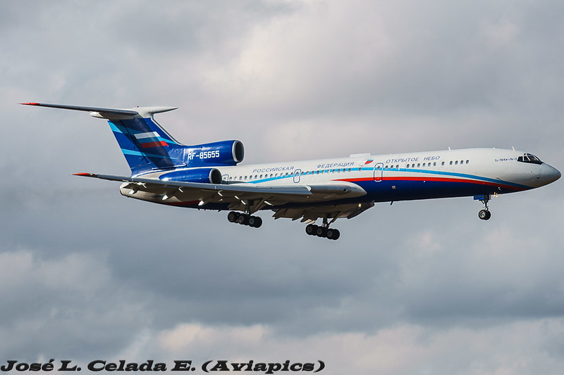
T-154M-LK1 RF-85655
I've written a lot about the Open Skies Treaty (here), and this week the Russian Federation Open Skies Treaty certified Tu-154M is once again in the skies over the United States.  There has been less media coverage this time, perhaps because the media didn't realize these flights normally happen once every month or two, and over cycled just weeks ago.  In short, 34 nations are signatory to the treaty, that lets the signatories overfly each others territory, with short notice, and members of the overflown nation's military on board, to take 30cm resolution pictures of sites of interest.  30cm is the defined maximum image resolution, and was the same when the Russian's used wet film.  The rest of the countries still use wet film, so far. This time, the Russians flew into Travis AFB on the West Coast, after stops for fuel in Iceland and Canada, and started observation flights Thursday March 18th 2017.  The flight plan would have been tabled either late Monday or early Tuesday, and a memo to all US Military (and related to military) sites that were going to be overflown would have been sent to ensure all unicorns were in their stables, and all stolen alien technology was back underground at Area 51, or, you know, whatever.

Here is a quick and dirty map of the locations they overflew. Why? Well, think of it this way. The sites that the RuAF are taking pictures of have been requested by the Russian Intelligence Community.  Something at these sites is interesting to someone, likely in the Russian defence industry.  But don't they have Google Maps?  Yes, but Google Maps / Bing / Nokia are all routinely tampered with by "Agencies", and the services are happy to do so to keep on governments' good sides. Entire airports can be removed and farms photo-shopped in. Buildings are over-exposed to blot out what's on top. Facilities are entirely pixelated.  Imagery is overtly tampered with, shadows moved, objects cloned. What you see on Google Maps is what the government is allowing you to see; Russia knows that.  While 30cm resolution isn't the greatest commercially available, it is good enough to show tanks loaded on rail cars, new buildings that have cropped up out of nowhere, etc.. They know their camera, and the pictures it takes, have not been tampered with.

Using its new-last-year Digital Electro Optical sensor, the flight has been basing itself out of Travis AFB in California, and at the end of the first day of observation flights, I believe it has taken pictures of the following locations, based on the altitude and airspeed.  Looking at the map below, and where you see a red dot, the plane was between 290-310kn, the sweet spot to take pictures.


Friday May 19th was the 2nd day of overflights and the Russians plotted a very similar route to what they flew in September of 2016.  Unfortunately, they varied their speed more than May 18th so it was a little harder to nail down exactly what they were taking pictures of.  My educated guesses are below:


With two observation flights complete, the Russians flew the first leg of their trip back to Moscow on May 20th, stopping for an overnight stay in Canada at CFB Trenton, which is a treaty approved refuelling stop.  All countries which are signatory to the Treaty on Open Skies must provide logistical support to Open Skies Treaty transit flights.